As a Ph.D. student studying the impacts of coastal flooding in Annapolis, Md., Miyuki Hino heard from people familiar with the area that rain caused flooding, but the conventional method of measuring floods wasn’t picking it up.
Tide gauges located in oceans and bays, which Hino and other scientists typically use to detect coastal floods, do not necessarily reflect flooding on land, leaving researchers, city planners, and forecasters with little information about how often these floods occur. As Hino, now an environmental social scientist at the University of North Carolina at Chapel Hill, and others revealed in a new study published in Communications Earth and Environment, installing instruments in inland communities can reveal even small-scale or sunny-day flooding that can affect residents.
“The goal of our project overall is to better answer how flooding is affecting people, businesses, and communities in low-lying areas.”
In the new study, the researchers placed low-cost flood sensors on land in three coastal North Carolina communities to study how often any type of flooding—from nuisance flooding to larger events—occurs.
“The goal of our project overall is to better answer how flooding is affecting people, businesses, and communities in low-lying areas,” Hino said. The new study takes a critical first step by measuring flooding accurately, she said.
Hino and Katherine Anarde, a coauthor on the study and a coastal engineer at North Carolina State University, hope the findings motivate other scientists to think critically about how and where they measure floods in their own research, especially as sea level rise makes coastal flooding more common.
Out with the Tide (Gauges)
Scientists typically define coastal flooding using thresholds determined by NOAA and the National Weather Service (NWS) that refer to certain tide gauge levels. These tide gauges sit in the ocean just offshore and measure the height of water as tides change.
NWS uses these measurements to issue watches and warnings for coastal flooding of varying severities. But often, those tide gauges don’t measure “where flooding is experienced by people,” said Paul Bates, a hydrologist at the University of Bristol who was not involved in the new study.
Tide gauges don’t account for every factor that may lead to coastal flooding, such as runoff from rainfall, contributions from groundwater, and the effects of drainage infrastructure. They’re also sparse. That means tide gauge levels—and flood warnings—don’t always match what people see on the ground.
To determine the scale of the problem, Hino, Anarde, and their colleagues installed networks of sensors and cameras near roadways and within storm drains in two towns and one unincorporated community in North Carolina: Beaufort, Carolina Beach, and Sea Level. The research team asked residents and municipal staff for the best spots to place the sensors to capture the actual flooding that the communities witness.
After a full year of monitoring, they found that the NOAA high-tide flood threshold and the NWS minor flood threshold, which both rely on tide gauge data, were not consistent with occurrences of inland flooding. In some cases, the inland sensors picked up flooding as much as 10 times more often than the tide gauges suggested. NOAA thresholds consistently missed inland flooding, whereas NWS thresholds both overestimated and underestimated flood frequency, depending on the community.
They also found that tide gauge data generally underestimated the duration of floods on land. One reason for the difference is that water may recede at a tide gauge fairly quickly but may take much longer to drain off land via stormwater infrastructure and groundwater infiltration.
The results “demonstrate the many benefits of measuring water levels on land rather than relying on tide-gauge-based estimates,” the authors wrote.
“There haven’t been many studies of this local-scale surface water flooding anywhere in the world because it’s so difficult to instrument,” Bates said. The new study is “one of the best empirical demonstrations” of the fact that water levels at the coast, as measured by tide gauges, are not a good indicator of flooding experienced inland, he said.
In their study, the researchers defined flooding as the presence of any water on a roadway, initially indicated by their sensors and confirmed by nearby cameras. When the camera view was obscured, a flood was counted when the sensors indicated water above the elevation of the roadway by at least the measurement error of their sensors. The shallowest flood measured in the study was 0.24 inch (0.6 centimeter), and the deepest was nearly 2 feet (61 centimeters).
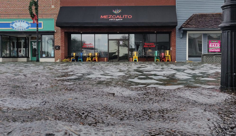
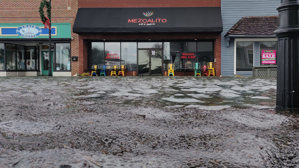
 Nuisance flooding, such as that seen here in Beaufort, N.C., is often not fully captured by tide gauges. Credit: Sunny Day Flooding Project/Flickr, CC BY-NC-ND 2.0
The study’s results may have been very different if the researchers had used a different definition of flooding, Bates pointed out. Flood events as defined in the study are very frequent and probably do not all create a nuisance for residents, he said.
The definition was chosen, Hino explained, because even small amounts of water can pose problems for some residents, depending on their needs. “We’re not in a position where we can say everybody needs to worry about flooding [at one depth], but no one needs to care [at another depth].”
For example, she said, driving through even a small puddle of salt water can spray water onto the underside of one’s car, which can cause corrosion. Relatively shallow floods can limit land use, depress property values, rust low-lying infrastructure, and contaminate flooded areas, according to the Sunny Day Flooding Project, of which the new research was part.
Meaningful Measurement
The sensors revealed what people across the state have been saying—that it’s flooding “all the time,” Anarde said. Because flooding is already posing problems for communities, the results increase the urgency of developing infrastructure solutions as sea levels rise, Hino said.
“The places that we think as scientists are important to measure may not be in line with what communities are interested in keeping dry.”
The data show that scientists aren’t always measuring the impacts of sea level rise and coastal flooding in places where such flooding affects communities, Anarde said. “The places that we think as scientists are important to measure may not be in line with what communities are interested in keeping dry.”
She recommends that scientists studying flooding focus on installing instrumentation in places where residents see frequent flooding, which has the added benefit of facilitating trust between residents and scientists, too.
“I don’t think our sensors are a silver bullet solution for measuring floods at every location,” Anarde said. “We can make our data useful in planning everyday activities by coming up with new ways to measure floods.”
—Grace van Deelen (@gvd.bsky.social), Staff Writer
Citation: van Deelen, G. (2025), Residents know when floods happen, but data must catch up, Eos, 106, https://doi.org/10.1029/2025EO250295. Published on 12 Auguste 2025.
Text © 2025. AGU. CC BY-NC-ND 3.0
Except where otherwise noted, images are subject to copyright. Any reuse without express permission from the copyright owner is prohibited.
Source:: Science – eos